ProfileBetween business, research and institutions
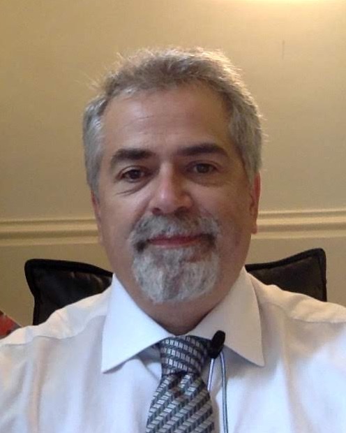
I started working at eighteen, selling computers while studying Computer Science. Soon afterwards I founded my first company, and for more than twenty years I led information technology businesses as entrepreneur and chief executive. Those companies grew into today's Genegis, which now employs about one hundred and fifty people.
While running those businesses I went back to the studies I had set aside and earned two degrees in Geographic Information Systems and Remote Sensing from IUAV University of Venice, both with full marks cum laude. In 2008 I joined the National Research Council of Italy through a public competition. At the Institute of Methodologies for Environmental Analysis, now the Institute of Integrated Methodologies for Earth Observation, I founded and led the geoSDI laboratory, later recognised as a Competence Centre of the Civil Protection Department for emergency prevention, planning and management.
Mine is a dual profile, civil and military. I have represented Italy at the United Nations and in Defence working groups, and I have brought the tools of research into major emergencies, from L'Aquila to Ischia. Since 2016 I have held senior institutional roles, including heading the Technical Secretariat of the Minister of Infrastructure and Transport during the crisis that followed the collapse of the Morandi bridge.
For the reconstruction of Ischia I built the island's digital twin and IRMAP, the system the European Investment Bank and the bodies involved use to follow construction sites in real time. Since March 2025 I have advised Extraordinary Commissioner Fabrizio Curcio on digital governance, and for four years I have assessed, for the National Research Council, the major industrial research projects backed by the Sustainable Growth Fund. The more personal side of this story is told in "Hello, World… my first 50 years", in Italian.
Choose a job you love, and you will never have to work a day in your life.Confucius
RolesCurrent roles
Reconstruction in Emilia-Romagna, Tuscany and Marche
I support the Commissioner in the digital governance of public and private reconstruction after the floods. The financial management, reporting and monitoring platforms I oversee follow over 7,500 public projects and nearly 7,000 private grant applications, against €4.1 billion of allocated funds. I also direct the execution of the information technology service contracts.
National Research Council of Italy
I head the geoSDI laboratory, National Competence Centre for geospatial data infrastructures, and I am the contact person for the CNR Geoportal for emergency support. I lead projects with the Civil Protection Department and with central and local government bodies.
Sustainable Growth Fund
I carry out the technical and scientific assessment of major industrial research and experimental development projects funded by the Fund, from appraisal through to progress monitoring.
Civil Protection and national security
I am a member of the working group set up by the Civil Protection Department for the national catalogue of civil protection plans, and of the Strategic Advisory Board of the National Security Observatory (OSSN).
Public contractsContract execution management
As contract execution director, I have overseen major data and platform contracts on behalf of the contracting administrations, from technical supervision of the work through to verification of compliance of what was delivered.
SIGEFIN
I directed the development of the financial management system of the reconstruction platform, which governs €4.1 billion of allocated funds, of which 3.3 for public and 0.8 for private reconstruction.
Land of Fires
I directed the development of the first drone piloting system dedicated to fighting the "Land of Fires" phenomenon in Campania.
Ischia mapping survey
I directed the aerial surveys and the production of the topographic database, 1:1000 digital mapping, orthophotos and digital terrain models of the municipality of Casamicciola Terme.
Campania regional technical map
I directed the update of the digital regional technical map and of the regional cartographic database.
PlatformsDigital platforms for reconstruction
The Government commissions I work with on the reconstruction of Ischia and of the flood-hit areas of Emilia-Romagna, Tuscany and Marche rely on platforms that combine geographic information systems, BIM modelling and artificial intelligence algorithms. These tools govern information flows from the single construction site to the overall financial picture and make the data available to citizens.
View the data as a table
| Item | Value | Share |
|---|---|---|
| In design | 848 projects | 13.4% |
| Being awarded | 236 projects | 3.7% |
| Under way | 642 projects | 10.1% |
| Completed | 4,547 projects | 71.8% |
| Data being updated | 64 projects | 1.0% |
View the data as a table
| Item | Value | Share |
|---|---|---|
| Requested | 500.12 € m | 45.2% |
| Granted | 372.38 € m | 33.6% |
| Paid out | 234.37 € m | 21.2% |
Open data on reconstruction
The Commissioner's public dashboard shows every project in the Special Reconstruction Plan with its progress status. They number 6,337 public projects worth about €2.9 billion, 4,547 of which are already completed. For private reconstruction, 6,818 applications have been processed and €372 million has been granted to families and businesses.
The dashboard covers the Special Plan only. Including emergency and urgent works, the public projects managed exceed 7,500. Official data on the Commissioner's website →
View the data as a table
| Item | Value | Share |
|---|---|---|
| Public reconstruction | 3,300.0 € m | 80.7% |
| Private reconstruction | 789.6 € m | 19.3% |
View the data as a table
| Month | Paid out |
|---|---|
| Jan | 0.0 € m |
| Feb | 0.0 € m |
| Mar | 0.0 € m |
| Apr | 0.0 € m |
| May | 1.3 € m |
| Jun | 25.0 € m |
| Jul | 20.2 € m |
| Aug | 36.5 € m |
| Sep | 16.1 € m |
| Oct | 4.2 € m |
| Nov | not yet |
| Dec | not yet |
From decree to payment
SIGEFIN follows every euro of the reconstruction, from payment requests and administrative decisions to payments and checks with CONSAP. It manages €4.1 billion of allocated funds, of which 3.3 for public and 0.8 for private reconstruction.
I directed its development as contract execution director. The system now brings together over 7,500 public projects and nearly 7,000 applications from families and businesses in a single environment serving the Commissioner's offices.
IRMAP
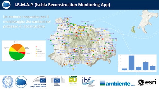
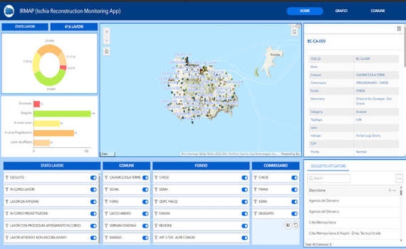
The Ischia Reconstruction Monitoring App distributes and controls the island's reconstruction sites. Every work is shown on the map and can be filtered by status, municipality, funding source, commission and implementing body.
The platform, which I designed for the Commissioner's office, is used by the European Investment Bank and all bodies involved to follow construction progress in real time, together with its financial, management and transparency aspects. With the island's digital twin, it became the model I later brought to reconstruction in Emilia-Romagna, Tuscany and Marche.
ExperienceFrom data to decisions
At Italy's seat
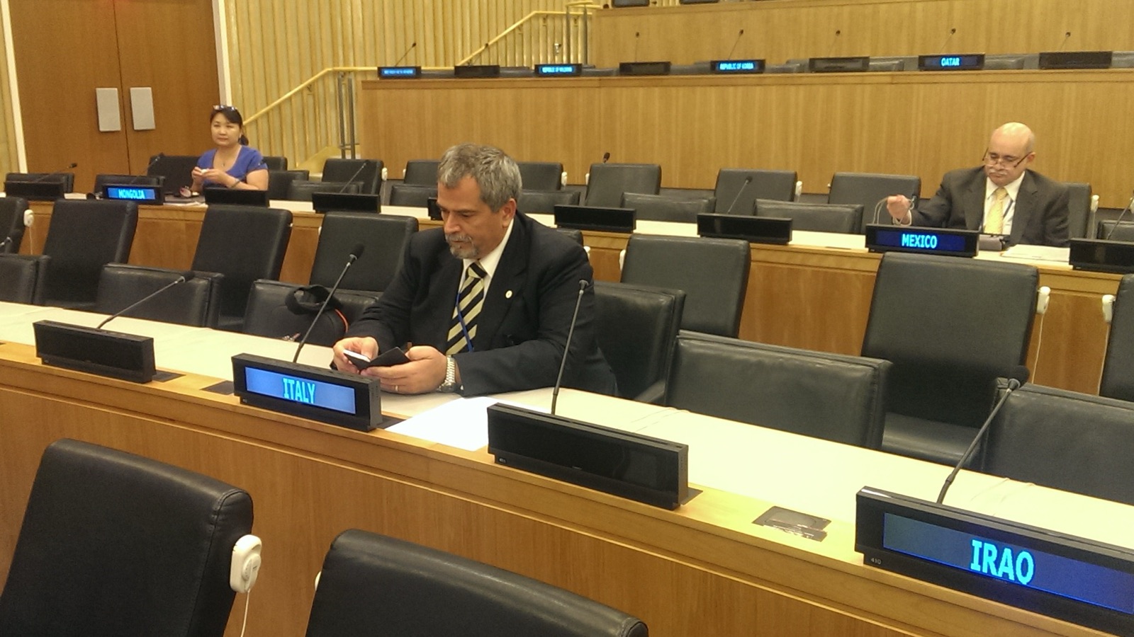
From 2014 to 2016 I was a member of the Italian delegation to the UN Committee of Experts on Global Geospatial Information Management, where countries agree common rules for producing and sharing territorial data, rules that become decisive in emergency management.
In the same years I was the delegate of the Italian Defence General Staff to DGIWG and, earlier, a European Commission expert for the INSPIRE Directive.
Real-time alerts
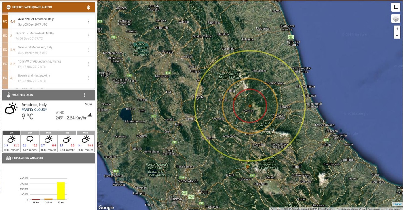
With the geoSDI laboratory I developed tools that turn data into operational decisions. Within minutes, E.W.A.R.E. combines seismic events, weather conditions and exposed population on a single map, with impact circles at 15, 25 and 50 kilometres.
That experience and the early warning system built in Zambia led to Comune Sicuro, a platform that connects regions, municipalities, volunteers and citizens during emergencies using the familiar patterns of social networks. "Nobody has ever read the Facebook or WhatsApp manual", I remarked when presenting the project, which in 2018 received the Sustainable PA Award at Forum PA.
"Thanks to what we have done, in the next emergency we will arrive a few days earlier than usual, and thousands of children will not die. The beauty of it is that nobody will ever know."
L'Aquila
I directed operational services for the Civil Protection Department at the DiCoMaC command centre during the earthquake, and then geospatial data management for the G8 summit.
Genoa
At the Minister's Technical Secretariat I managed the crisis after the Morandi bridge collapse and oversaw the launch of AINOP and ANSFISA.
Ischia
I built the island's digital twin and IRMAP, used by the EIB and all bodies to follow construction sites in real time.
Floods
I oversee the digital governance of reconstruction in Emilia-Romagna, Tuscany and Marche, covering over 7,500 public projects and €4.1 billion of funds.
PlacesMy work in Italy and abroad
Around the world
- 2014–2016New York · United Nations, UN-GGIM
- CNR · geoSDISan Francisco and Mountain View · CNR, agreement with Google
- CNRAlgeria and Tunisia · CNR projects
- 2013–2015Ecuador · UN projects
- 2013–2015Galápagos · World Food Programme
- 2013–2015Palestine · World Food Programme
- 2013–2015Zambia · World Food Programme
- 2013–2015Congo · UN projects
- business yearsToronto · Foreign Ministry missions, as a young entrepreneur
- business yearsMontréal · Foreign Ministry missions, as a young entrepreneur
- business yearsVancouver · Foreign Ministry missions, as a young entrepreneur
In Europe
- 2007–2017DGIWG, Defence delegate · Belgium, Canada, England, Norway, Slovenia, Spain, Sweden, Turkey, Ukraine
- 2004–2009Luxembourg · Eurostat, INSPIRE expert
- 2004–2009Paris · INSPIRE Directive
- 2004–2009Brussels · INSPIRE Directive
- 2004–2009Innsbruck · INSPIRE Directive
- business yearsAlbania · with IG S.p.A., as a young entrepreneur
In Italy
- since 2025Emilia-Romagna, Tuscany, Marche · post-flood reconstruction
- 2008–todayRome · CNR, Ministry, Presidency of the Council
- 2017–2026Ischia · reconstruction, Digital Twin and IRMAP
- 2016–2020Naples · Campania Region, Chief of Staff
- 2018Genoa · Morandi bridge collapse
- 2016–2017Amatrice · earthquake and E.W.A.R.E. alerts
- 2007 · 2014Venice · IUAV, two degrees
- 2009L'Aquila · earthquake, DiCoMaC and G8
- 2004–2009Ispra · European Commission, INSPIRE Directive
- 2004–2009Sardinia · INSPIRE Directive
- 2008Tito (Potenza) · CNR IMAA, geoSDI is born
- 1986Montella · roots and first company
Hovering over or tapping a point, a highlighted country or a list entry lights up the matching items together. Lists run from the most recent.
CareerProfessional career
-
2022 – today
Reconstruction and major projects
- Since March 2025 I have been advisor to Extraordinary Commissioner Fabrizio Curcio for reconstruction in Emilia-Romagna, Tuscany and Marche. I oversee the digital governance of public and private reconstruction after the floods, covering over 7,500 public projects, nearly 7,000 private applications and €4.1 billion of allocated funds, and I direct the execution of the information technology service contracts.
- Since 2022 I have carried out, for the National Research Council, the assessment of major industrial research projects funded by the Sustainable Growth Fund of the Ministry of Enterprises and Made in Italy, from appraisal to progress monitoring.
- From 2022 to 2026 I was information technology advisor to the Extraordinary Government Commissioner for the reconstruction of Ischia, through Invitalia. I built the digital twin of the intervention area, combining BIM models, GIS data, surveys, mapping and artificial intelligence, and IRMAP, the site distribution and control system adopted by the European Investment Bank and all bodies involved for real-time monitoring, including finance and transparency. I also directed the execution of the contracts for aerial surveys, topographic database, orthophotos and digital mapping of Casamicciola Terme.
- I directed the execution of the contracts for SIGEFIN, the financial management system for reconstruction in Emilia-Romagna, Tuscany and Marche, for the Campania regional technical map and cartographic database (2022–2024), and for the first drone piloting system against the "Land of Fires" phenomenon.
-
2016 – 2020
Government roles
- I was Chief of Staff of the Regional Council of Campania (2019–2020) and coordinated the work of the Conference of Presidents of Italian Regional Councils.
- I was Head of the Technical Secretariat of the Minister of Infrastructure and Transport (2018–2019), managing the crisis after the Morandi bridge collapse and the launch of ANSFISA and of the national public works information archive (AINOP).
- I sat on the steering committee of the Presidency of the Council of Ministers for the action plan against waste fires in the "Land of Fires" (2019–2020).
- I sat on the technical committee for reconstruction after the Ischia earthquake (2017–2019).
- I was Head of the Technical Secretariat of the Vice President of the Campania Regional Government (2016–2017).
-
2008 – 2016
CNR IMAA, geoSDI laboratory
I founded and led the geoSDI (geo Spatial Data Infrastructure) laboratory, National Competence Centre for geospatial data, whose platform underpins the National Integrated Civil Protection System.
- I directed operational services for the Civil Protection Department at the DiCoMaC command centre during the 2009 L'Aquila earthquake, and geospatial activities for the G8 summit.
- I coordinated the MITO project, a network of territorial information laboratories with Parthenope University, Politecnico di Bari, the University of Palermo and ISPRA.
- I led United Nations projects in Palestine, Zambia, Congo and Ecuador and worked with NASA, Google and major industrial groups.
-
1986 – 2008
Business and consulting
I was a business owner and then founder and chief executive of Computer Master and GeosLab, the companies from which today's Genegis grew, with about 150 employees. I was selected among innovative young entrepreneurs for Ministry of Foreign Affairs trade missions. As a consultant I advised Computer Associates on GIS for the public sector, and I worked with SDA Bocconi, the Ministry of the Environment and the Civil Protection Department on European projects.
ExpertiseMy areas of expertise
- Territorial data governance
- Geospatial data infrastructures
- GIS and BIM
- Digital Twins
- Artificial intelligence
- Earth observation
- Emergency management
- Post-disaster reconstruction
- Public sector digital transformation
- Public works monitoring
- Big Data and Cloud
- International data standards
- ICT contract management
- Industrial research project assessment
InternationalInternational roles
INSPIRE Directive
I was selected by the European Commission as an expert in the Drafting Team for the Implementing Rules on monitoring and reporting.
UN-GGIM
I was a member of the Italian delegation to the Committee of Experts on Global Geospatial Information Management.
DGIWG
I was the delegate to the Defence Geospatial Information Working Group for the definition of international geospatial data standards.
World Food Programme
I was focal point of the memorandum of understanding between CNR IMAA and the World Food Programme, and coordinated activities with WFP in Palestine.
PublicationsPublications and contributions
41 citations and h-index 3 on Google Scholar · 23 articles in INGENIO Figures updated October 2026.
Scientific publications
- SAFE (Safety for Families in Emergency): a Citizen-Centric Approach for Risk ManagementSebillo, Vitiello, Grimaldi, Dello Buono · ICCSA 2019, Springer · 201912 citations
- VIGOR: Sviluppo geotermico nelle Regioni della ConvergenzaAlbanese, Allansdottir, Amato et al. · CNR · 20147 citations
- Enhancing the spatial dimensions of open data: geocoding open PA information using geo platform fusion to support planning processIzzi, La Scaleia, Dello Buono, Scorza, Las Casas · ICCSA 2013, Springer · 20133 citations
- Civil Protection 2.0: a Diagram-based Approach for Managing an Emergency PlanDello Buono, Vitiello, Sebillo, Risi, Grimaldi · AGILE 2019 · 20192 citations
- HELP: an Early Warning dashboard System for the prevention, mitigation and assessment of disasters, with open data and open source technologiesAmato, Dello Buono, Izzi, La Scaleia, Maio · PeerJ Preprints · 20162 citations
- A national early warning system for rainfall-induced landslides in ItalyGuzzetti, Rossi, Peruccacci, Brunetti, Marchesini, Ardizzone et al. · AGU Fall Meeting, San Francisco · 20101 citation
- Earth Observation data and Software as a Service solutions for time series analysisDello Buono, Lapenna, Cuomo, Lanari et al. · ESA Big Data from Space (BiDS'14) · 2014
- Satellite analysis of vegetation cover for the enhancement of natural areasImbrenda, Lanfredi, Dello Buono, Coluzzi, Simoniello · Towards Horizon 2020 · 2013
- A spatial data infrastructure to disseminate information on geo-hydrological hazards and risk in ItalyDello Buono, Guzzetti et al. · Geophysical Research Abstracts, EGU · 2011
- Implementazione di tool on-line per la gestione dei rischi naturali ed antropici nell'area Euro-MediterraneaDello Buono, Amato, Izzi, La Scaleia, Maio · 2010
- Il riordino dei Servizi Cartografici Nazionali. Situazione, tecnologie, prospettive ed opportunitàDello Buono · Tesi, IUAV Venezia · 2006
- The integrated action framework of Rete Natura 2000 BasilicataTrotta, Bentivenga, Borghetti, Caniani, Costantini et al.
INGENIO articles (in Italian)
- BIM per contrastare il dissesto idrogeologico: la tecnologia c'è ma non sappiamo utilizzarlaINGENIO, 2025
- Decreto Intelligenza Artificiale: proposte, critiche e osservazioni suggerite dalla IA stessaINGENIO, 2024
- Alluvione Ischia 2022: Gemello Digitale per una ricostruzione efficace ed intelligenteINGENIO, 2023
- Siamo pronti per la digitalizzazione delle infrastruttureINGENIO, 2021
- La riforma del catasto. Situazione tecnologie e prospettiveINGENIO, 2021
- Transizione Digitale Sostenibile delle CostruzioniINGENIO, 2021
Show all 23 articles
- Digitalizzazione: quando ci sono in ballo vantaggi economici tutto cambia, anche l'attenzione alla privacy.INGENIO, 2020
- DL. RIlancio: Non si chiama più Sisma Bonus.INGENIO, 2020
- APP CORONAVIRUS: cosa ci salverà il GPS o il Bluetooth ?INGENIO, 2020
- Mai più come primaINGENIO, 2020
- Tecnologia Digitale: Ecco cosa impareremo da questa emergenzaINGENIO, 2020
- Occorre un modello per la gestione delle emergenze, quale metodo per gestire la crisi da Covid-19?INGENIO, 2020
- App del CNR, online in tempo reale. Una mappa 'social' con informazioni della area del sismaINGENIO, 2020
- Progetto MITOINGENIO, 2020
- ICT & IOT: avremo 655.571 miliardi di miliardi di dispositivi connessi ?INGENIO, 2018
- Chi è il GIM? Per metà cartografo, per metà informatico con declinazioni statisticheINGENIO, 2015
- Il senso dell'Open DataINGENIO, 2013
- Uno più Uno fa TreINGENIO, 2013
- La gestione delle risorse territoriali in modo condivisoINGENIO, 2013
- Open Data, Open Software e la Cooperazione sul WebINGENIO, 2013
- Open data per risparmiareINGENIO, 2012
- Open Data e GIS - Intervista a Dimitri Dello Buono, Resp. Centro di Competenza per la Spatial Data Infrastructure del DPCINGENIO, 2012
- SaaS - Software as a ServiceINGENIO, 2012
Other journals
- Come un uso corretto e sistematico dei dati può aiutare nella gestione delle catastrofiL'Ingegnere Italiano, n. 378 «Emergenze», 2021
- Sistema di analisi, divulgazione e utilizzo delle informazioni geospaziali dei borghi della Campania per il supporto del turistaGEOmedia, con M. Bruno, 2012
- geoSDI: dal GIS allo scenario Web SharedGEOmedia, 2010
- geoSDI ERA: gestire le emergenze in maniera integrata e condivisaGEOmedia, 2009
MediaInterviews and awards
"Persone", interview by Franco Genzale
A professional and personal journey, from Montella to national institutions.
Irpinian of the Year 2018
The award ceremony.
Sustainable PA Award 2018
Comune Sicuro, the civil protection platform developed by the geoSDI laboratory I led, was named best project in the Cities, infrastructure and social capital category. Il Mattino also reported on it under the headline "An app to make us feel safer".
EducationStudies and training
- 2014
Master's degree in Territorial, Urban and Environmental Planning
IUAV University of Venice, Geographic Information Systems and Remote Sensing · 110/110 cum laude
- 2007
Bachelor's degree in Urban, Territorial and Environmental Planning
IUAV University of Venice, Geographic Information Systems and Remote Sensing · 110/110 cum laude
- 1991 · 1996
Master's programmes in business culture and management
LUISS · SDA Bocconi
ContactGet in touch
For collaboration proposals, institutional requests and professional enquiries, please write to me at the addresses below or consult my curriculum vitae.