ProfileBetween research, business and institutions
I started working at eighteen, selling computers while studying Computer Science. A few years later I founded my first company, and for more than twenty years I worked as an entrepreneur and CEO in the ICT sector; those companies grew into today's Genegis, which now employs about 150 people. Along the way I went back to the studies I had set aside: two degrees in Geographic Information Systems and Remote Sensing from IUAV University of Venice, both with full marks cum laude.
In 2008 I joined the National Research Council (CNR) through a public competition. At the Institute of Methodologies for Environmental Analysis (IMAA) I founded and led the geoSDI laboratory, which became a Competence Centre of the Civil Protection Department for emergency prevention, planning and management. Mine is a dual, civil and military profile: I have represented Italy at the United Nations and in Defence working groups, and brought research into major emergencies, from L'Aquila to Ischia.
Since 2016 I have held senior institutional roles, including heading the Technical Secretariat of the Ministry of Infrastructure during the Morandi bridge crisis. For the Ischia reconstruction Commissioner I built the island's Digital Twin and IRMAP, the system the European Investment Bank and all bodies involved use to follow construction sites in real time. Since March 2025 I have advised Fabrizio Curcio, Extraordinary Commissioner for Reconstruction in Emilia-Romagna, Tuscany and Marche, on digital governance. And for four years I have been assessing, for CNR, the major industrial research projects funded by the Sustainable Growth Fund of the Ministry of Enterprises and Made in Italy.
Choose a job you love, and you will never have to work a day in your life.Confucius
TodayCurrent roles
Reconstruction in Emilia-Romagna, Tuscany and Marche
Digital governance of public and private reconstruction after the floods: platforms for financial management, reporting and monitoring of about 7,000 projects worth about €5 billion. Contract execution director for ICT services.
CNR, geoSDI laboratory
Head of the laboratory, National Competence Centre for geospatial data infrastructures, and of projects with the National Civil Protection and with central and local government bodies.
Sustainable Growth Fund
Technical and scientific assessment of major industrial research and experimental development projects funded by the Fund, from appraisal to progress monitoring.
Civil Protection and national security
Civil Protection Department working group for the national catalogue of civil protection plans. Strategic Advisory Board of the National Security Observatory (OSSN).
Public contractsContract execution director
As contract execution director (DEC), I have overseen major data and platform contracts on behalf of public administrations, from technical supervision of the work to verification of what was delivered.
SIGEFIN
Development of the financial management system of the reconstruction platform, which handles over €3 billion.
Land of Fires
Development of the first drone piloting system to fight the "Land of Fires" problem in Campania.
Ischia mapping survey
Aerial surveys, topographic database, 1:1000 digital mapping, orthophotos and terrain models of Casamicciola Terme.
Campania regional technical map
Update of the digital regional technical map and of the regional cartographic database.
In the fieldWhere data becomes decisions
At Italy's seat
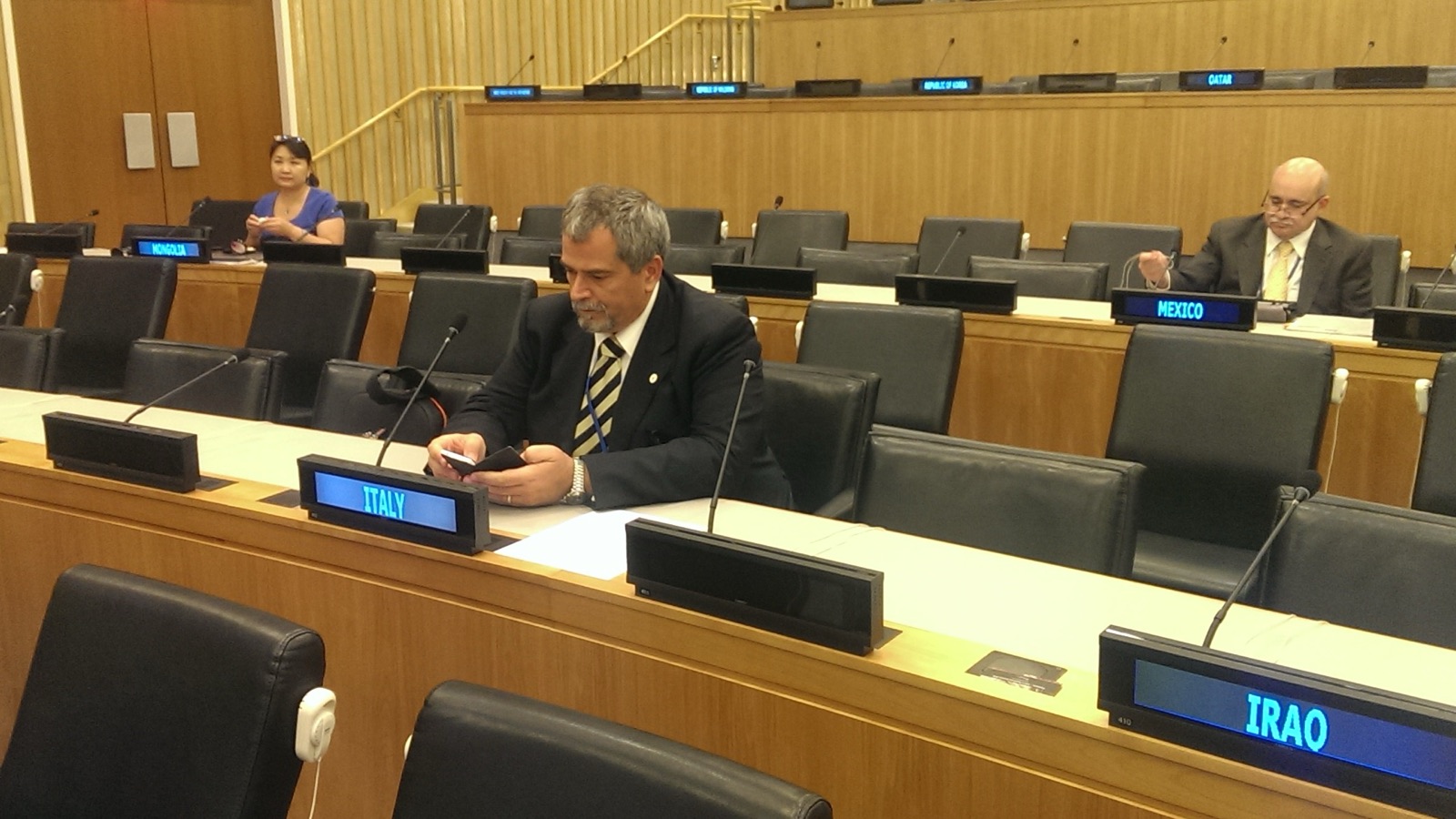
For three years I was part of the Italian delegation to the UN Committee of Experts on Global Geospatial Information Management. It is where countries agree on how to produce and share data about the territory: common rules that become decisive when an emergency strikes.
In the same years I was the Defence delegate to DGIWG and, before that, a European Commission expert for the INSPIRE Directive.
Real-time alerts
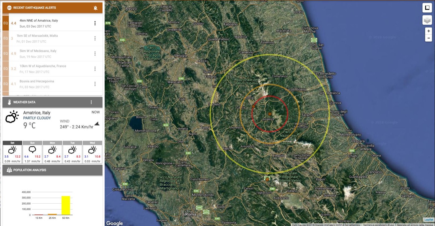
With the geoSDI laboratory we built tools that turn data into decisions. Within minutes, E.W.A.R.E. combines earthquakes, weather and exposed population on a single map, with impact circles at 15, 25 and 50 kilometres.
The same work led to the HELP and Comune Sicuro apps, bringing civil protection information straight to citizens.
"Thanks to what we have done, in the next emergency we will arrive a few days earlier than usual, and thousands of children will not die. The beauty of it is that nobody will ever know."
L'Aquila
The earthquake: operational services for Civil Protection at the DiCoMaC command centre, then geospatial data for the G8.
Genoa
The Morandi bridge collapse, handled by the Ministry's Technical Secretariat; then AINOP and ANSFISA.
Ischia
The island's Digital Twin and IRMAP, used by the EIB and all bodies to follow construction sites in real time.
Floods
Emilia-Romagna, Tuscany and Marche: digital governance of about 7,000 reconstruction projects.
PlacesWhere I have worked
Around the world
- 2014–2016New York · United Nations, UN-GGIM
- business yearsToronto · Foreign Ministry missions, as a young entrepreneur
- business yearsMontréal · Foreign Ministry missions, as a young entrepreneur
- business yearsVancouver · Foreign Ministry missions, as a young entrepreneur
- CNR · geoSDISan Francisco and Mountain View · CNR, agreement with Google
- 2013–2015Ecuador · UN projects
- 2013–2015Galápagos · World Food Programme
- 2013–2015Palestine · World Food Programme
- 2013–2015Zambia · World Food Programme
- 2013–2015Congo · UN projects
- CNRAlgeria and Tunisia · CNR projects
In Europe
- 2004–2009Luxembourg · Eurostat, INSPIRE expert
- 2004–2009Paris · INSPIRE Directive
- 2004–2009Brussels · INSPIRE Directive
- 2004–2009Innsbruck · INSPIRE Directive
- 2007–2017DGIWG, Defence delegate · Belgium, Canada, England, Norway, Slovenia, Spain, Sweden, Turkey, Ukraine
- business yearsAlbania · with IG S.p.A., as a young entrepreneur
In Italy
- 2004–2009Ispra · European Commission, INSPIRE Directive
- 2004–2009Sardinia · INSPIRE Directive
- 2007 · 2014Venice · IUAV, two degrees
- 2018Genoa · Morandi bridge collapse
- since 2025Emilia-Romagna, Tuscany, Marche · post-flood reconstruction
- 2016–2017Amatrice · earthquake and E.W.A.R.E. alerts
- 2009L'Aquila · earthquake, DiCoMaC and G8
- 2008–todayRome · CNR, Ministry, Presidency of the Council
- 2017–2026Ischia · reconstruction, Digital Twin and IRMAP
- 2016–2020Naples · Campania Region, Chief of Staff
- 1986Montella · roots and first company
- 2008Tito (Potenza) · CNR IMAA, geoSDI is born
Hover over or tap a point, a coloured country or a place in the list.
CareerFour professional seasons
-
2022 – today
Reconstruction and major projects
- Advisor to Extraordinary Commissioner Fabrizio Curcio for reconstruction in Emilia-Romagna, Tuscany and Marche (since March 2025): digital governance of public and private reconstruction after the floods, about 7,000 projects worth about €5 billion, contract execution director for ICT services
- Assessment of major industrial research projects funded by the Sustainable Growth Fund of the Ministry of Enterprises and Made in Italy (since 2022): technical and scientific analysis for CNR, from appraisal to progress monitoring
- Reconstruction of Ischia (2022–2026): ICT technical advisor to the Extraordinary Government Commissioner, through Invitalia. Digital Twin of the intervention area, combining BIM models, GIS data, surveys, mapping and artificial intelligence; IRMAP, the site distribution and control system used by the European Investment Bank and all bodies involved for real-time monitoring, including finance and transparency; contract execution director for aerial surveys, topographic database, orthophotos and digital mapping of Casamicciola Terme
- Contract execution director for SIGEFIN, the financial management system for reconstruction in Emilia-Romagna, Tuscany and Marche, for the Campania regional technical map and cartographic database (2022–2024), and for the first drone piloting system to fight the "Land of Fires" problem
-
2016 – 2020
Government roles
- Chief of Staff of the Regional Council of Campania (2019–2020), coordinating the Conference of Presidents of Italian Regional Councils
- Head of the Technical Secretariat of the Minister of Infrastructure and Transport (2018–2019): the Morandi bridge collapse, the creation of ANSFISA and of the national public works information archive (AINOP)
- Member of the Presidency of the Council's steering committee for the action plan against waste fires in the "Land of Fires" (2019–2020)
- Member of the technical committee for reconstruction after the Ischia earthquake (2017–2019)
- Head of the Technical Secretariat of the Vice President of the Campania Regional Government (2016–2017)
-
2008 – 2016
CNR IMAA, geoSDI laboratory
Founder and head of the geoSDI (geo Spatial Data Infrastructure) laboratory, National Competence Centre for geospatial data and the basis of the framework of the National Integrated Civil Protection System.
- Head of operational services for the Civil Protection Department at the DiCoMaC command centre during the 2009 L'Aquila earthquake, and of geospatial activities for the G8 summit
- Coordinator of the MITO project, a network of territorial information laboratories with Parthenope University, Politecnico di Bari, University of Palermo and ISPRA
- United Nations projects in Palestine, Zambia, Congo and Ecuador; collaborations with NASA, Google and major industrial groups
-
1986 – 2008
Business and consulting
Business owner, then founder and CEO of Computer Master and GeosLab, which grew into today's Genegis (about 150 employees); selected among innovative young entrepreneurs for Ministry of Foreign Affairs trade missions. Consultant to Computer Associates on GIS for the public sector, and to SDA Bocconi, the Ministry of the Environment and the Civil Protection Department on European projects.
AreasWhat I work on
- Territorial data governance
- Geospatial data infrastructures
- GIS and BIM
- Digital Twins
- Artificial intelligence
- Earth observation
- Emergency management
- Post-disaster reconstruction
- Public sector digital transformation
- Public works monitoring
- Big Data and Cloud
- International data standards
- ICT contract management
- Industrial research project assessment
InternationalBodies and delegations
INSPIRE Directive
Selected as an expert in the Drafting Team for the Implementing Rules on monitoring and reporting.
UN-GGIM
Member of the Italian delegation to the Committee of Experts on Global Geospatial Information Management.
DGIWG
Delegate to the Defence Geospatial Information Working Group on international data standards.
World Food Programme
Focal point of the CNR IMAA – WFP memorandum of understanding and coordinator of activities with WFP Palestine.
PublicationsArticles and research
Recent articles (in Italian)
- Intelligenza Artificiale e Legislativa: un dialogo generativoArtificial intelligence and lawmaking: a generative dialogue · INGENIO, 2024
- Un Gemello Digitale di Ischia per una gestione della ricostruzione efficace e intelligenteA Digital Twin of Ischia for effective, intelligent reconstruction · INGENIO, 2023
- ICT & IoT: avremo 655.571 miliardi di miliardi di dispositivi connessi?ICT & IoT: will we have 655,571 billion billion connected devices? · INGENIO, 2023
- Siamo pronti per la digitalizzazione delle infrastrutture?Are we ready to digitalise infrastructure? · INGENIO, 2021
- Come un uso corretto e sistematico dei dati può aiutare nella gestione delle catastrofiHow correct, systematic use of data can help manage disasters · L'Ingegnere Italiano, 2021
- Occorre un modello per la gestione delle emergenzeWe need a model for emergency management · INGENIO, 2020
Research
- Civil Protection 2.0: a Diagram-based Approach for Managing an Emergency PlanDello Buono, Vitiello, Sebillo, Risi, Grimaldi · AGILE 2019
- SAFE (Safety for Families in Emergency): a Citizen Centric Approach for Risk ManagementSebillo, Vitiello, Grimaldi, Dello Buono · ICCSA 2019, Springer
- HELP: an Early Warning Dashboard System for the prevention, mitigation and assessment of risksAmato, Dello Buono, Izzi, La Scaleia, Maio · PeerJ Preprints, 2016
- Earth Observation data and Software as a Service solutions for time series analysisDello Buono, Lapenna, Cuomo, Lanari et al. · ESA Big Data from Space (BiDS'14), 2014
- Satellite analysis of vegetation cover for the enhancement of natural areasImbrenda, Lanfredi, Dello Buono, Coluzzi, Simoniello · Towards Horizon 2020, 2013
- A spatial data infrastructure to disseminate information on geo-hydrological hazards and risk in ItalyGeophysical Research Abstracts, EGU 2011
- A national early warning system for rainfall-induced landslides in ItalyAGU Fall Meeting, San Francisco, 2010
MediaInterviews (in Italian)
"Persone": interview by Franco Genzale
A professional and personal journey, from Montella to national institutions.
Irpinian of the Year 2018
The award ceremony.
Comune Sicuro
"An app to make us feel safer": civil protection in citizens' hands.
EducationStudies
- 2014
Master's degree in Territorial, Urban and Environmental Planning
IUAV University of Venice, Geographic Information Systems and Remote Sensing · 110/110 cum laude
- 2007
Bachelor's degree in Urban, Territorial and Environmental Planning
IUAV University of Venice, Geographic Information Systems and Remote Sensing · 110/110 cum laude
- 1991 · 1996
Master's programmes in business culture and management
LUISS · SDA Bocconi